Dubai's Peri-Urbanity: An investigation on the city’s desert side.
Paper selected for oral presentation @ The 4th Memaryat International Conference MIC 2020, Designing for the Desert 26th - 27th of February - Jeddah, KSA
Abstract. Traditionally, the city/countryside dichotomy is understood through the difference between the high density of volumes, functions, social relations of the urban context, and the low density of the extra-urban territory. In recent research, Rem Koolhaas argues that the western rural areas have reached a degree of specialization and exploitation in which it is difficult to recognize the traditional conception of natural territory. The same extra-urban regions are also affected by recent phenomena of migration that, through a slow de-urbanization, moves from city centers to re-colonize agricultural zones. In hyperarid cities like Dubai, how are peri-urban areas different? In a region where the arable surface does not reach one point of percentage, what is the role of the "Desert-Side"? This paper aims to provide a holistic understanding of Dubai's extra-urban areas.
Keywords: Dubai, Peri-Urban, Rural, Villages, Infrastructure, Urbanism, Desert.
1 The Question of the Country-Side
In 2009, the number of inhabitants residing in urban centers had surpassed that of residents in extra-urban areas. [1] This datum could be defined as historical significance, but it is not an unexpected event. The urbanization process that began with the first industrial revolution of the late nineteenth century never ended even though it occurred at different speeds in specific cultural and geographical areas. [2]
If at first, the western cities of the world witnessed a sudden increase in the population, in the last decades, the phenomenon has been predominant in the south-east regions of the planet. Research on contemporary urbanism has produced a vast amount of material by analyzing the phenomenon of morphological transformation and its social and economic meanings from the historical to the contemporary city. The analysis was carried out according to multiple points of view, starting with the nature of its territorial expansion. Perhaps, it may not be far from reality to say that much has been said to understand the sometimes organic and self-reproductive nature of the contemporary urban context. The city considered the place of social aggregation, has in the "country-side" its antagonistic territorial dimension. The latter has undergone as many processes of profound transformation as the first, but perhaps it has not attracted the same attention of architects and urban planners. Scholars have not felt the same urgency to investigate the territorial transformation inherent in the "country-side" considered for many years, the place of absence of urbanity, and mainly intended to support the needs of urban civilization under scrutiny. [3]
The above is the thesis of Rem Koolhaas, who, in an article published in the magazine Icon in 2014, turns perhaps for the first time, the attention of urban research to extra-urban areas. He discussed their radical change, especially in terms of the perception of their traditional 'naturalness.' The country-side examined by Koolhaas is the place of intensive exploitation of the productive capacity of food and materials coming from agriculture.
However, it is also a landscape that has profoundly changed its social identity. Its population has changed from indigenous to global with the addition of a new generation of immigrants who take the place of traditional and local workers no longer willing to bear the tremendous low-yielding labor of agricultural production. The latter has radically changed by introducing almost totally mechanized work processes to maximize the production and exploitation of resources. Koolhaas also looks at the new types of buildings built to host the mentioned production, starting with "server farms" and ultra-technological greenhouses. They are anonymous and almost "mysterious," due to their total lack of spatial relationship with the surrounding context. The architecture of these productive devices transcends the form-function matrix to the point of completely nullifying any semiological properties. Koolhaas gives a decisive definition of the contemporary country-side: "A world formerly dictated by the seasons and the organization of agriculture is now a toxic mix of genetic experiment, science, nostalgia, seasonal immigration, territorial buying sprees, massive subsidies, incidental inhabitation, tax incentives, investment, political turmoil, in other words, more volatile than the most accelerated city." [4]
In an attempt to analyze more precisely the transformation of the western suburban areas, Koolhaas examines a rectangle of the Dutch country-side dimensions of 12 x 3 kilometers. The list of functions in that area shows an unusual density of activity more adequately related to an urban context even if relatively dispersed in the agricultural territory. "The landscape of the intermediate" is a type of territory that combines the features of the traditional country-side with the relevant functions of a consolidated urban fabric. Therefore, in the Western context, many territories have undergone profound morphological and social transformations, so profound as to change the traditional historical conformations into new models of settlement. A reflection on the deep understanding of these phenomena and the consequent transformations that inform new settlements and new typological palimpsests is therefore necessary. The analysis of the "intermediate" context will then lead to necessary cognitive bases to produce appropriate and suitable project proposals, especially set regarding the sustainability of the territorial system and its architecture.
2 The Desert Side
Koolhaas' analysis seems to focus on specific European territorial realities. Probably, the awaited exhibition 1 "Country-side, The Future," which will take place at the Guggenheim in New York, will include issues on a global level. The exhibition "will examine the modern conception of leisure, large-scale planning by political forces, climate change, migration, human- and non-human ecosystems, market-driven preservation, artificial and organic coexistence and other forms of radical experimentation that are altering the landscapes across the world." [5]
In this paper, we try to transfer the conceptual apparatus of this research from Europe to the context of the Gulf countries and, more specifically, to the peri-urban and rural areas of Dubai, to outline possible similarities and to highlight the most likely differences. For obvious geographical reasons, these areas do not have the same characteristics that one can find in European cities. Therefore, first of all, one needs to classify the territory from a climatic and morphological point of view. It is difficult to arrive at an unambiguous definition of the climate of the UAE. It is generally classified as hyper-arid, but within the country, there are different bio-climatic zones. [6] Aridity is usually expressed concerning the amount of rainfall and temperature and, as described in the definition provided by the Food and Agriculture Organization of the United Nations, hyper-arid areas are dryland areas mostly without vegetation. In these zones, nomadic pastoralism is frequently practiced, and annual rainfall is low, rarely exceeding 100 millimeters. The rains are infrequent and irregular, sometimes with no rain during long periods of several years. [7]
In this specific environment, "limited amounts of freshwater, in combination with extremely high summer temperatures and high evaporation rates, make the Arabian Peninsula a harsh environment for the people, fauna, and vegetation" [8] Therefore, one should consider both the urban expansion of cities and the birth and development of desert settlements in relation to the availability of water. In the Emirates, this natural element is so essential that it is considered a fundamental aspect of the cultural heritage. [9] Moreover, on a geographical level, the location of oases configured the paths of the traditional merchant routes that crossed the desertified territories. These paths traveled since ancient times by the commercial caravans proceeded from one oasis to another to stock up on water. 2 The presence of water in the oases allowed survival and, although limited, agricultural production while crossing caravans allowed exchange and trade. These factors explain the origin and permanence of traditional settlements in the inhospitable desert of the Arabian Peninsula.
Therefore, it is a question of density. The morphology of the western country-side, taken into consideration by Koolhaas, is mostly homogeneous. In terms of habitability, the cultivated plains of the Netherlands do not undergo the radical difference between the morphological characters of desert and oasis. In most parts of Europe, the density is constant and evenly distributed, and the exploitation of the territory is intense. The Netherlands is a small country with a high density of more than 1,300 inhabitants per square mile. [10] Instead, Dubai's peri-urban and rural areas substantially differ. The density of housing and agricultural production is concentrated near oases in quantities and sizes that are much lower. These places are an exception to the hegemonic landscape of the desert. French philosopher Michel Foucault would call them heterotopies: places of 'Otherness' and of 'Marginality' – 'sites' of difference in relation to the hegemonic space of society that surrounds it. [11] Their presence is, in fact, sporadic, and they are functionally specialized.
The 2020 Dubai Masterplan defines the desert areas "Non-urban area 1" and "Non-urban area 2." In the Spatial Structure Plan of the Urban Development Parameters, area 1 is recognized for its regional role of open recreational area as well as camel breeding and the presence of some critical infrastructures such as the Al Maktoum international airport. "Non-urban area 2" comprises Dubai's rural and natural hinterland. It is intended to "primarily serve agricultural, conservation, and village lifestyle functions. It also has the potential to accommodate essential facilities required to support Dubai's urban communities, including waste management and water storage facilities."[12] It is in this portion of the territory that the so-called Non-urban settlements, often integrated with agricultural areas, are concentrated. They are considered by the masterplan to be essential for Dubai's future growth to be protected while preserving its quality and defended by a possible incipient urban sprawl.
For this reason, and to keep the natural aspects of the landscape intact, "to support values such as biodiversity, agricultural production, landscape heritage, and outdoor recreation," an urban edge beyond which urbanization is strictly controlled, was placed alongside the Outer Bypass Road. In the Non –urban areas allowed features and functions are as follows: low-density residential, ultra-low (non-urban) residential, conservation, agriculture, cemeteries, community facilities, Eid prayer areas, local retail, public open space, recreation facilities, and religious facilities. The desert side is also included in the two focus areas of the masterplan within the metropolitan Sector 7: Conservation reserves and Non – urban settlements. "Within this sector is remnants of projects that are on hold, some smaller-scale projects that have recently been completed, and some rural desert villages scattered throughout."[13] The desert side is also included in the two focus areas of the masterplan within the metropolitan Sector 7: Conservation reserves and Non – urban settlements. "Within this sector is remnants of projects that are on hold, some smaller-scale projects that have recently been completed, and some rural desert villages scattered throughout."[13]
3 The Rectangle in the Desert
Considering the above, in order to conduct the same analysis undertaken by Koolhaas in his research, but to arrive at a correct typological and functional understanding of the peri-urban and rural areas of Dubai, the size of the rectangle taken into consideration must be modified.

Fig. 1. The chosen territorial sample. Highways are (lines) connecting oasis (circles) (Source: From the Author)
The geographical sample must enclose a more significant area and include the road arteries along which the settlements are allocated. Therefore, we assume a rectangle of 32 x 24 kilometers that frames an area representative of the desert-side of Dubai. The first thing that can be noticed is the presence of the traditional green areas of the farms. The plots of agricultural land are sporadic fragments in Dubai’s territory. In 2017, out of the 388500 hectares of the whole land, only 317.7 were cultivated for field crops / fodders, and 176.5 were for vegetables. [14] The will of the Sheikh Zayed Bin Sultan Al Nahyan was different. Starting from the assumption that the Arabian Peninsula was a very different place thousands of years ago full of forests and green grasslands, the father of Dubai, expressed the dream, perhaps utopian, of restoring the lush plains present in a bygone era. In short, the Sheikh dreamed of combating desertification and intensifying agriculture. The effects of such vision, not entirely achieved, can be seen along the road from Abu Dhabi to Al Ain, where there are many local farms. The Sheikh did not reach the dream of turning the desert into a green paradise. However, he succeeded in promoting specific directives to start a more rigorous environmental awareness in the local culture. [15] Farms are often associated with the presence of rural settlements, although not in a large number. These residential clusters are predominantly agglutinations that settle along roads and highways where, especially for those closer to urban centers, it is not rare that groups that enjoy particular economic well-being reside. In 2018 there were a total of 150,605 buildings in the emirate of Dubai, of which only 8,291 were in the "rural" areas. [16]
Thanks to housing development programs implemented by governmental authorities such as the Sheikh Zayed Housing program, the Bedouin temporary settlements around the 1960s started to turn into permanent residential communities. With the massive process of rapid urbanization, substantial differences have emerged between the economic level of the inhabitants of urban centers and those in the further rural areas of the emirate. As a result, some members of the desert-side communities have moved to the cities looking for better job opportunities and living standards. The government authorities have provided aid mainly aimed at optimizing local agricultural revenues and diversifying sources of income to counter this migration. Furthermore, road infrastructures have been improved, and missing services such as schools, low-cost houses, and primary urbanization works have been provided. [17]

Fig. 2. The territorial “Rectangle” showing functions (Source: From the Author)
There is an evident uniformity in the typological solutions adopted for the settlements' planimetric organization. The same master plan layout is systematically used in almost every flat plot of land. It is based on the perimeter positioning of the residences (mostly made up of single-family villas) around an area reserved for ancillary community functions. In many cases, apart from the construction of the mosque, these spaces remained empty and are still awaiting the arrival of services such as schools, kindergartens, clinics, etc. It is interesting to note that the same layout plan, which in the absence of a specific definition in this venue we define "spin-wheel," is used indifferently in the desert-side and the central areas of Dubai. An aerial view of an area in Jumeirah can show how the residences of an urban block delimited by roads are similarly arranged to that of desert settlements. However, in this case, the central zone, considered too valuable, has been occupied by other residences.

Fig. 3. Samples of “Spin-Wheel” Arrangement for Desert Settlements (Source: From the Author)
Nevertheless, in the desert-side of Dubai, traditional farms and connected residences are present in a considerably smaller number than any other functions. The "Non-urban area" is the place where oil is extracted and refined, but also the place of industrial production and new forms of energy exploitation. "The Mohammed bin Rashid Al Maktoum (MBR) Solar Park […] comprises 800 megawatts (MW) and is part of what will be the largest single-site solar park in the world, with a planned capacity of 5,000MW by 2030." [18] Moreover, there are many functions directly connected with the touristic vocation of the emirate. In this sense, the Desert-side is a geographical extension of hotels' facilities. It is part of the program of recreational activities often included in the packages offered by travel agencies. Locations inspired by Bedouin camps provide the basis for explorations of the fascinating desert landscapes. Dinner buffets and oriental theme shows dot the desert at night. Finally, there are also numerous venues for sports and recreational activities. The sizeable available area and the low cost of the land attract sporting functions, like parachuting, that need considerable unobstructed, free surface. The presence of specialized equipment for single events is another functional feature of these areas.
The "Sevens Stadium" is home to the Emirates Airline Dubai Rugby Sevens, built to house the annual event sponsored primarily by the air company. It is capable of holding up to 50,000 spectators, and is located far away from the center of Dubai, along the highway that connects the city to Al Ain. The structure is equipped with some fields for practicing different sports, but it also contains a banquet area, conferences/meeting rooms, etc. Furthermore, the stadium also offers the possibility of hosting large-scale musical events. The Sevens Stadium would constitute, citing Foucault again, another heterotopia. This time not only intended as a physical utopia but also influenced by the temporal space. According to Foucault, it is a "hetero-cronia." The real use of the structure is limited to a reduced number of days in which the hugely successful rugby event takes place. The attempt to use the recreational compound in the rest of the year, in addition to the youth rugby school, seems to be unsuccessful given the limited events on the calendar.
Camel breeding takes place in particular areas that follow a carpet-like layout, alternating fences, stables, and housing for workers in the sector. The functional center of these areas is the camel race track that attracts a large number of predominantly local enthusiasts to attend seasonal competitions. [19] The animal symbol of the Arabian Peninsula, known as "the ship of the desert" has a long tradition of symbiotic relationship with the human being. If historically the camel was used as a means of transport and as a food resource, today it still retains an essential role in the Emirate society. Many Bedouin families still own these animals from which they get their milk and are sacrificed during cultural festivals. [20] Contemporary agricultural and industrial processes now modify even the centuries-old tradition of camel breeding. Dubai authorities invest in cutting-edge camel breeding technology and embryo transfers. Moreover, cloning is being pioneered and structured fertilization methods are applied to artificially increase production. [21]
4 The Desert is an Extension of the City
The desert-side of Dubai, in peri-urban and rural areas, contains multiple, either historical or added in modern times, varieties of functions. Contemporary new technologies, inform their spatiality and urbanization. The desert of Dubai, although a place with much lower housing and functional densities than the urban areas, is an evolving system, certainly not static. It is a territory mainly used to support global tourism, which is one of the significant economic assets of the emirate. Furthermore, it is also the place for specialized industrial and agricultural processing and grants its large spaces to the activities of governmental institutions.
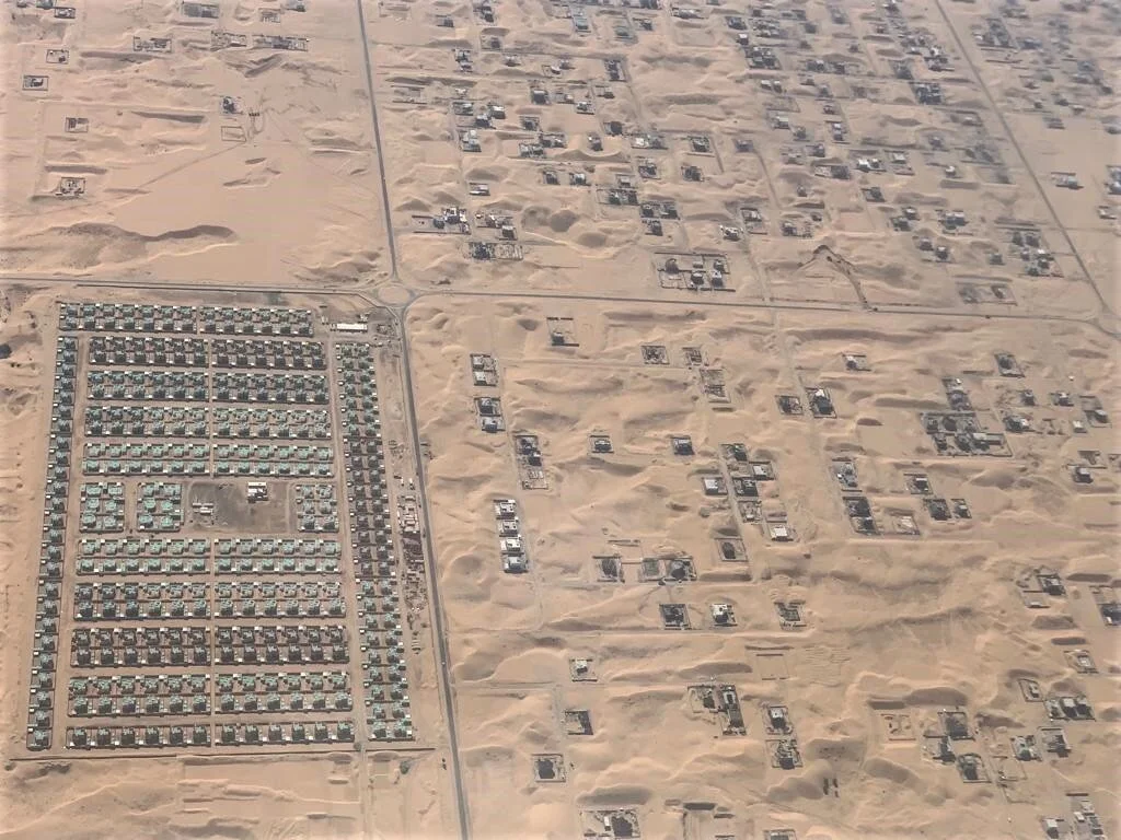
Fig. 4. Aerial view of the desert-side of Dubai (Source: Viraj Chatterjee)
The territorial planning, through the Dubai masterplan 2020, provides general indications of respect and conservation of the desert settlements. In theory, it considers the possibility of limited volumetric expansions and functional additions to support the habitability of the outer areas. In practice, one can already foresee another story. The 2020 masterplan already highlighted the lack of a residential product accessible to the lower and middle classes, especially of the expats' community. The vast majority of residential buildings built in the last few years in Dubai targeted the most affluent component of society.
For this reason, many residents working in Dubai are forced to look for a residence with more affordable rents in the neighboring Sharjah and Ajman, and consequently, they are also forced to commute to work. The transhumance of about 200,000 workers among the emirates is the cause of the massive level of traffic that accumulates along the main highways, considered a real social plague for those who daily suffer from it. The economic situation in Dubai (2019) has, however, led to a change in the city's urban growth strategies. After the crisis of 2008 and the positive peak of 2014, the value of real estate properties and the cost of their rent decreased of about 35% in five years. [22]
If, on the one hand, the residential over-supply has caused the creation of a government committee in charge of evaluating new projects (according to not so clear economic feasibility parameters), on the other, forced the major property developers to turn their attention to new markets.
The affordable housing sector seems to be the new horizon of development. After all, families living in adjacent Emirates since 2018, have already begun moving to the outlying areas of Dubai thanks to the collapse in rental prices. The natural outlet for this new thrust of urban growth is, therefore, the desert with its cheap land. Located on Dubai - Al Ain highway, which is expected to double in maximum capacity, and "designed for residents who desire a balanced lifestyle," The Emaar's "The Valley" will consist, if the original project is completed, of "4,500 residential units spanning an area of 200 hectares". [23] A better look at the general masterplan suggests that the number of units may be much higher, even up to 16000 units. The satellite city is positioned well beyond the 2020 urban edge. Called a "self-contained town" [24] by the chairman of the property developer company, "The Valley" is the first substantial step in Dubai's growth beyond its peri-urban boundary.
The future of the desert side of Dubai is, therefore, uncertain. If, on the one hand, the cultural value of the territory and its peculiar landscape is recognized, on the other, the temptation of massive urban development in areas that are still intact seems to be incipient. Furthermore, the need to develop suitable urban design strategies and building typologies that can primarily respond to a necessary and no longer postponed ecological and sustainable approach does not seem to have been taken into consideration by the regional architectural practice.
Notes:
1 This text was written in November 2019.
2 Observing the alignment of modern roads with the oases of the Arab Emirates this intuition has been confirmed by Rashad Bukhash Head of Heritage Department of Dubai.
References
1. United Nations, "Urban and Rural areas 2009" https://www.un.org/en/development/desa/population/publications/urbanization/urban-rural.asp
2. Changing Forms. Urbanization. https://en.wikipedia.org/wiki/Urbanization
3. Steel, C.: Hungry City: How Food Shapes Our Lives. Chatto & Windus, London (2008)
4. Koolhaas, R.: Rem Koolhaas: countryside architecture. https://www.iconeye.com/architecture/features/item/11031-rem-koolhaas-in-the-country
5. Countryside, The Future. https://www.guggenheim.org/exhibition/countryside
6. Böer, B.: An introduction to the climate of the United Arab Emirates. Journal of Arid Environments. Volume 35, Issue 1, January 1997
7. The arid environments. http://www.fao.org/3/t0122e/t0122e03.htm
8. Böer, B.: An introduction to the climate of the United Arab Emirates. Journal of Arid Environments. Volume 35, Issue 1, January 1997, Pages 3-16
9. Ghazal, R.: Al Ain oasis still watered by 200-year-old irrigation system. https://www.thenational.ae/uae/heritage/al-ain-oasis-still-watered-by-200-year-old-irrigation-system-1.427720
10. Viviano, F.: This tiny country feeds the world. https://www.nationalgeographic.com/magazine/2017/09/holland-agriculture-sustainable-farming/
11. Foucault, M.: The Order of Things. Vintage Books. New York (1971)
12. Dubai Masterplan 2020. 04 Urban Development Parameters. Dubai 2020 Spatial Structure Plan Report, Page 30. Dubai Municipality. Dubai (2011)
13. Dubai Masterplan 2020. 03 Metropolitan Sectors. Dubai 2020 Staging Plan Report, Page 25. Dubai Municipality. Dubai (2011)
14. Distribution of Land Use - Emirate of Dubai, Dubai statistics center https://www.dsc.gov.ae/en-us/Themes/Pages/Agriculture,-Livestock-and-Fisheries.aspx?Theme=27
15. Emirates investment Corporation. Zayed vision: Transforming desert into green haven https://emic.ae/zayed-vision-transforming-desert-into-green-haven/
16. Dubai Statistics Center. Buildings by Type and Location (Urban/ Rural) - Emirate of Dubai (2018) https://www.dsc.gov.ae/en-us/Themes/Pages/Housing-and-Building.aspx?Theme=40
17. Cordes, R.; Scholz, F.: Bedouins, Wealth, and Change: A Study of Rural Development in the United Arab Emirates and the Sultanate of Oman, United Nations University, Tokyo (1980)
18. Shuaa Energy 2. https://masdar.ae/en/masdar-clean-energy/projects/mohammed-bin-rashid-al-maktoum-solar-park-phase-3
19. Al Lawati, A.: "Future of camel breeding" https://gulfnews.com/uae/future-of-camel-breeding-1.835339
20. Salem, F.: "Camels a key part of UAE's rich heritage."https://gulfnews.com/uae/camels-a-key-part-of-uaes-rich-heritage-1.603548
21. Al Lawati, A.: "Future of camel breeding" https://gulfnews.com/uae/future-of-camel-breeding-1.835339
22. UBS Global Real Estate Bubble Index 2019 https://www.ubs.com/global/en/ubs-news/r-news-display-ndp/en-20190930-grebi-global.htm
23. "Emaar Properties launches The Valley." https://www.khaleejtimes.com/business/real-estate/emaar-properties-launches-the-valley
24. Fahy, M. "Dubai's Emaar Properties launches Dh25bn The Valley community." https://www.thenational.ae/business/property/dubai-s-emaar-properties-launches-dh25bn-the-valley-community-1.938760